 Filter: Categories of Wisconsin Historical Images
Filter: FORMAT_DIMENSIONS of 49 x 59 cm.
Filter: Categories of Wisconsin Historical Images
Filter: FORMAT_DIMENSIONS of 49 x 59 cm.

| Date: | 1888 |
|---|---|
| Description: | This late 19th century map of Price County, Wisconsin, shows landownership and waterfront acreages, the township and range system, towns, cities and villag... |

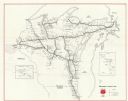
| Date: | 1975 |
|---|---|
| Description: | This 1975 road map of Columbia County, Wisconsin, shows the location of historic sites in the county but lacks a key to those sites. It includes an inset m... |

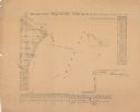
| Date: | 1835 |
|---|---|
| Description: | These maps of the towns of Westport, Madison, and Blooming Grove, Dane County, Wisconsin, show sections, roads, trails, lakes and streams, and wetlands fro... |
| Date: | 1856 |
|---|---|
| Description: | Shows sections and acreages. Covers portions of the area now occupied by Marinette and the Town of Peshtigo, Marinette County. "Rec’d Sept. 24 with Sur. Ge... |
| Date: | 1990 |
|---|---|
| Description: | This map shows main railroad track, lines out of service, abandoned lines, and trackage rights. The back of the map shows Wisconsin Central Ltd. lines and ... |
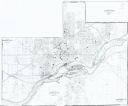
| Date: | 1985 |
|---|---|
| Description: | This photocopied map shows the area as it appeared in 1889. The map shows buildings, lot numbers, some landownership, and the Fox River. |

| Date: | 1739 |
|---|---|
| Description: | This map shows the territorial claims of the western hemisphere by the European powers, as well as the names of major cities, geographical features, and pa... |

| Date: | 1770 |
|---|---|
| Description: | Map of North America from the Great Lakes to the northern portion of South America. It shows cities, Native American land, mountains, swamps, lakes, rivers... |

| Date: | 1784 |
|---|---|
| Description: | Map of the southeastern region of America to just west of the Mississippi River. It shows borders, cities, towns, forts, Native American land, portages, mo... |
If you didn't find the material you searched for, our Library Reference Staff can help.
Call our reference desk at 608-264-6535 or email us at: